
-
 The Carlson RT5 is a ruggedized Windows data collector designed for surveying, stake-out, construction layout and GIS mapping, and is bundled with Carlson SurvPC – the Windows based data collection program. Optionally, the RT5 can run SurvPC with esri OEM for use in the field. With 8GB of RAM, 256 GB of storage, you can collect and analyze your data quicker than ever before. See More Product Info
 -

 The Carlson RT4+ is designed for surveying, stakeout, construction layout, and GIS mapping and is bundled with Carlson SurvPC – the Windows-based data collection program. The RT4+ can also be used in the office with any Carlson office software. With Windows 11, 16GB of RAM and 256 GB of storage, you’ll have the power to collect and analyze your data faster and more efficiently than ever before. See More Product Info
 -

 The Carlson RT4 tablet is designed for surveying, stakeout, construction layout, and GIS mapping. It is bundled with Carlson SurvPC – the Windows-based data collection program. SurvPC includes the option of running the Esri OEM program for GIS field work. The RT4 can also be used in the office with any Carlson office software. With 8GB of RAM and 128 GB of storage, you’ll have the power to collect and analyze your data faster and more efficiently than ever before.
 -
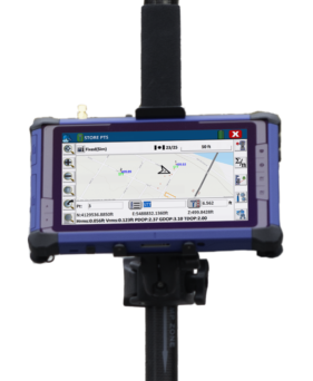
 Introducing the Carlson RTk5: Empowering Precision and Flexibility in GNSS Technology Experience unparalleled freedom and precision with the Carlson RTk5, a cutting-edge GNSS solution seamlessly integrated into the RT5. Packed into a compact, lightweight, and versatile package, this advanced device revolutionizes your surveying, engineering, GIS, and GNSS positioning needs. The Carlson RTk5 comes equipped with a range of essential features and accessories designed to enhance your productivity. Its custom-built pole and cradle provide stability and convenience, ensuring seamless operation in any environment. With the inclusion of a survey-grade antenna, you can achieve superior accuracy for your land surveying projects. For on-the-go applications, we have included a small, portable helix antenna specifically tailored for handheld GNSS use. This empowers field professionals with the flexibility to capture precise positioning data on the move. GNSS CAPABILITIES • Advanced multi-frequency, multi-constellation (GPS + GLONASS + Galileo + BeiDou + QZSS) RTK GNSS performance • Balanced & ergonomic; 25+% lighter than typical GNSS setups – 6 lbs (2.7 kg) with tablet, cradle, pole, and antenna • Gather live, centimeter-level positions directly into an Esri database with zero post processing • Operate handheld without a pole for fast GIS work


Who We Are
Allenbuild Instruments LLC
Address: Turning Point Drive, Wake Forest, NC 27587, USA
Tel: +1 (919) 761-5140
Email: Click here to email us
Quick Links

© Copyright 2025 | Allenbuild Instruments | All Rights Reserved | Designed by Sally Compton